Dahlfin II Status

| Last updated: July 29, 2004 |
Dahlfin II Status |
|
|
||
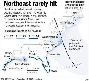
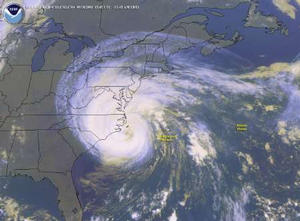
106) Phone message from Annapolis, MD
9-16-03 Ron and Bonnie called to say they are in Spa Creek in
Chesapeake Bay. Hurricane Isabel is headed their way and due to make landfall
on Thursday night. Currently Isabel is a Category 5 hurricane with winds in
excess of 150 mph. They are a little bit east of the hurricane's path so they
are on the "bad side" (the rotational wind and the forward motion of the
hurricane add to produce even stronger winds - hurricanes rotate
counter
clock-wise in the northern hemisphere). They have found a place to leave
the boat on a mooring and have made reservations at a hotel nearby for Thursday
and Friday.
-Peter
 |
 |
|
 |
 |
 |
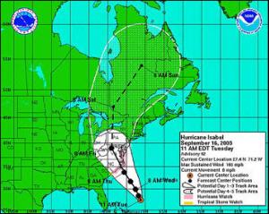
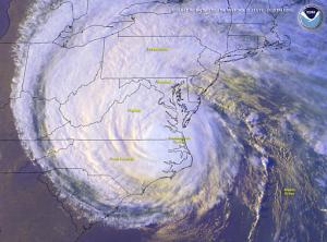
107) Phone message from Annapolis, MD
9-18-03 Ron and Bonnie called to say they have checked into the hotel and Isabel has made landfall in North Carolina. They found a brand-new mooring (anchored with a large 12' long and 3' diameter "screw" into the soft mud) to leave the boat at. The soft mud in Chesapeake Bay is hard to get an anchor to set, the anchor just plows through the mud. They removed the 3 roller furling head-sails and the bimini but left the mainsail and the dodger on. Isabel has decreased in strength to Category 2 and has windspeeds of 100 mph. According to the weather reports Isabel came ashore in North Carolina and by the time it hit Annapolis the winds had decreased to 80 mph.
They considered heading to the western shore of the Chesapeake Bay early
in the week. This was considered too "iffy", they would be on the good side of
the hurricane's path but they would have to stay with the boat since that area
is more remote. They would still have to deal with the storm surge and the
trees and debris in the creeks. As it turned out, the hurricane came ashore
further south than originally expected and so the western Chesapeake would have
been directly in the path and so there would have been no advantage from where
they were (western shore of Chesapeake Bay).
-Peter
 |
 |
 |
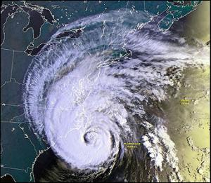
108) Email from Spa Creek, MD
9-21-03 We are both ok, the boat is ok. Once again we were very lucky that the hurricane was downgraded from a Category 5 to Category 2 as it approached shore. It lost some of its punch as it moved over land. Landfall was on the Carolina Coast south of us at around 11 am Thursday. By 4 pm we began to feel strong winds which increased through the night. Interestingly, we received very little rain (only about 3 inches): the western hemisphere of the hurricane got all the rain, the eastern hemisphere (our hemisphere) received the stronger winds. How much wind? We don't know because we weren't at the boat. But in talking with a homeowner next to where we were anchored, he said there were sustained winds in the range of 50 to 60 knots, with gusts a little higher.
We had lots of challenges from Sunday, when we arrived at Annapolis, to Thursday as we watched the hurricane march towards us and made our preparations. We were very fortunate to get on a vacated mooring for a 45 foot boat mid-Monday. There were only 6 moorings in the field and we took our place with the 45 and 50 footers. On Tuesday we stripped the boat, removing the bimini, 3 head-sails, life-rings and all loose gear. We also doubled up on the mooring lines. Although we had great confidence in the mooring which was just put in this season: an embedded 12 foot iron rod 3 inches in diameter, with 3 sets of spiral blades 3 ft in diameter (this is called a helix mooring - a giant screw in the sea-bed), we were concerned about chafe both at the mooring ball and on the boat deck. Because of this we had to remove both of our bow anchors because these could have cut the lines as the boat danced around. That was a hard decision, putting the anchors down below - but then we reasoned there would be no one on board to use them.
For those of you who have been to Annapolis, we were up Spa Creek beyond the bridge, which was reasonably well protected. All but a few of the boats in the Annapolis area were tied to marina docks or on moorings. Many that were on docks, moved to moorings. In Spa Creek there were only 4 boats on anchor: 2 sailboats, 1 trawler, and a catamaran tied to shore. The creek like the rest of the Chesapeake is characterized by soft mud making it difficult to get a good set with any anchor. The Annapolis Harbor Master cleared all boats off the city dock (Ego Alley) and all the moorings in the outer harbor. There were 4 boats anchored in the outer harbor on Wednesday. One moved around to the Severn River, the other three were lost: two sunk as they dragged into the Naval Academy shoreline, one was lifted up and deposited on the rocks.
One of the hardest decisions we had to make was what to do with the dinghy when we got to shore. Anticipating a storm surge of at least 5 feet (the actual storm surge ended up being over 6 ft) we finally ended up using a private floating dock owned by a gracious woman who gave us permission to use it. Working with a couple from Nova Scotia on early Thursday morning we two women were ferried ashore. Then Ron and Hill (the other fellow) put away the motors of both dinghys, tied our dinghy across the stern or our boat in the water and rowed ashore in their dinghy. They then turned it upside down on the floating dock and lashed it down.
Then it was about a mile trek to the hotel and wait. We had done everything we could. The next morning, Ron and Hill went down to check on the boats. What a wonderful message it was that I received by portable VHF that both boats looked ok. The dinghy on the floating dock however, was 200 feet away because of the rise of the water up unto the woman's lawn. Fortunately 2 kayaks came by, untied the dinghy and brought it up shore to them (otherwise they would have had to swim for it!). Jenny and I took a long and detoured cab ride with the luggage to where they were. The detours were due to the fact that many streets were still flooded or had trees down.
None of the boats that we were with sustained any damage. Considering the number of boats in Annapolis it appears as though there was very little damage - except for the 3 lost in the outer harbor. Many of the people on shore were left without electricity - especially the whole southern side of Spa Creek.The greatest effect of the storm was the 6 ft storm surge and many waterfront stores, especially Pusar's received considerable damage. The town is now coming back to order even though many waterfront stores are still closed and boarded up (Sunday).
In closing: As you can well imagine, we had a lot of anxiety this past week. We are very very thankful that we are alright and the boat is ok. And so the adventure continues.
109) Email from Great Bridge (Beginning of ICW)
10-8-03 Lake Superior to the ICW (2003)
After getting a couple of e-mail requests "to get back on the web page", belatedly I write. My apologies for not attending to this sooner and I will try to bring you up to date - and then do a better job keeping in touch.
After a rather challenging spring "fitting out" (we put in a new engine among other things), we left Port Superior on 1 June to head out into the Apostle Islands for a few days to unwind and relax before crossing to Isle Royale. We made the crossing on 5 June with no wind, so it was a good opportunity to continue breaking in our new engine.
It had been some time since we had been on the island this early in the season and we enjoyed the freshness of new growth and newly hatched waterfowl as we slowly worked our way around the south and north ends of the island. After 12 days on the island, using our Remote Border Crossing Permit, we crossed directly from McCargo's Cove to Walker's Channel at Porphry. Thus began one of our favorite segments on the lake and we spent a month on the North and East Shores visiting all our favorite anchorages, taking in the best that Lake Superior has to offer. We expected it to be cool, and it was. But we also had some very good sailing as the weather systems moved through. Again, as on Isle Royale, we did as much hiking as we could.
In Sault Ste Marie we spent about 5 days (on both sides) stocking up on provisions before heading south to Lake Huron. Once again, as in 1996, we left Detour Light behind and headed south on Lake Huron. Huron proved a challenge to us because of extremely low water - 0.02m above chart datum (0.78 in). There were only 3 places we could get into with our 6 ft plus draft along the western side of the lake: one anchorage (Presque Isle), a commercial harbor (Harbor Beach) and one marina (Harrisville) where we just skimmed in on very thin water. Thus, we had some long days on Lake Huron, but were able to take advantage of westerly winds. We flew down the St. Clair and Detroit Rivers, clipping along at 8.0-8.5 knots on the 2 1/2 knot current. (The thought of coming back up "the down stair case" is not very appealing.)
Lake Erie was much better on depth (2 1/2 feet above chart datum) and we were able to make shorter jumps: Put-in-Bay, Cleveland, Ashtabula, Erie, Dunkirk. On the eastern end of Lake Erie at North Tonawanda (suburb of Buffalo, NY), we took down the mast at Wardells with the help of other boaters.
This was our third trip on the Erie Canal and it certainly was more pleasant than in the spring of 2000 when we were stopped many times by flooding waters. The canal is definitely a different kind of boating and we loved it as we wound through tranquil countryside and by picturesque villages crossing upper New York State.
Once again, we stepped the mast at Riverview at Catskill and then continued our way down to the Hudson to New York City. We tried to stay on a mooring at the 79th Street Marina, but found it too bouncy and ended up at a wonderful anchorage (new for us) behind the Statue of Liberty. Neat. We spent a few days at Great Kills on Staten Island and again took the train and then the Staten Island Ferry over to Manhattan where we paid homage to Ground Zero from 9/11 - a very moving experience for us.
The trip down the Jersey Coast was uneventful with stops at Atlantic City and Cape May. (The Farley State Marina at Atlantic City now charges $4/foot! We were fortunate to stay for free at a boatyard across the way.) From Cape May we were able to time the tides just right so we were able to sail the full length up Delaware Bay AND then transit the C&D canal to the Bohemia River in the upper Chesapeake all in one day: 72 nm in 9 1/2 hours, averaging 7.5 knots!
We planned on spending the month of September in the Chesapeake to avoid hurricanes before heading further down the coast. Thus we spent a lot of time in the Sassafras River & then in Baltimore where we attended the Soundbound Cruisers Reunion which was 3 days of excellent pertinent sessions for those of us headed south. It was our first exposure to the cruising community since leaving home and we made many friends who we continue to see in anchorages along the way.
Then came Isabel of which you have our accounts in the three previous reports. Interestingly it was those of us on boats who recuperated more quickly than those on land who experienced a lot of flooding, trees down and power outages for over a week. Because we are pretty much independent and self-contained, making our own electricity etc., all we had to do was put the sails back on, bimini up etc. By the way, we now have confirmed accounts of sustained 70 knot winds just 40 miles south of where we were. I also forgot to mention in the hurricane report that all but a few cruisers in Spa Creek left their boats and went to hotels. Our hotel had 60% occupancy with people from boats. In true cruising fashion, many of us transient cruisers in Spa Creek held a potluck and barbeque cookout on the Saturday night after Isabel to celebrate our good fortunes in coming through the hurricane. It was a wonderful party.
After Isabel we crossed over to the eastern shore going up a number of small creeks, visiting St. Michaels and Cambridge. We wanted to visit more anchorages but felt that we had to now keep on moving to make up for time lost in Baltimore and Annapolis. Crossing back over to Solomons on the western shore, we continued down the western shore to Fort Monroe at the bottom of the Chesapeake. As before, sailing by Navy Alley into Norfolk was a thrill and we marveled at the aircraft carriers, submarines and destroyers. We are presently at Great Bridge near the beginning of the ICW, approximately 12 miles SE of Norfolk and are beginning to see a lot more severe hurricane damage. They just reopened the waterway a week ago (the Dismal Swamp is still closed), but we are told there are 800 markers that are damaged or out of position. Our plan is to stock up here, do laundry etc. and then continue down the ICW.
110) Update from Vero Beach, Florida
The ICW: Great Bridge, Virginia to Vero Beach, Florida
After leaving Great Bridge, we continued on the ICW on what is known as "The Virginia Cut" to Coinjock. We crossed Albemarle Sound in a Small Craft Advisory with a 20 knot north wind at our back which made for a very quick crossing. The next few nights were spent in beautiful wilderness anchorages. One of our favorite stopovers on the ICW is Oriental, NC where we had a layover day before continuing to Beaufort, NC which is on an ocean inlet, the first of many we were to encounter.
We now traveled very close to the ocean for many days, separated only by the Barrier Islands. Along this stretch, most of the islands support endless miles of dense wall-to-wall housing. Further south, many of the Barrier Islands are quite austere consisting of sand dunes windswept with beach grass. We were careful to negotiate the Cape Fear River on an ebb tide, as it is quite a slog to buck an incoming current down to the ocean.
Continuing on the ICW, we now began to encounter a number of bridges. One bridge in particular (Sunset Beach Highway Bridge) is so archaic that it opens on a pontoon via a cable. Because of this, it can't operate at low tide and we were held up for 2 hours waiting for sufficient water to come in. A word about bridges on the whole ICW: we noticed that many of the previous opening bridges we had passed through in 1996 are now 65 ft. highrises (at least a dozen) which really makes for quicker transit.
In South Carolina we took a couple of layover days at another of our favorites: Barefoot Landing at Myrtle Beach. There is a free dock here adjacent to an up-scale mall consisting of dozens of novelty shops, outlet stores, and restaurants which are tastefully built in sections via boardwalks over a marsh. It was also our first chance to walk to the ocean and do a little beach combing. Not far from Barefoot Landing we found ourselves winding through dense Cypress swamps, an almost surrealistic experience with Spanish moss hanging from the trees and no apparent firm land anywhere, just water going back in as far as we could see amidst the trees. We pulled off and anchored in one of the many side channels for the night.
We had a number of other stops where we took layover days. One was at Georgetown SC, a quaint little fishing village where we anchored adjacent to numerous shrimping trawlers. It was a good place to stock up on supplies, do some laundry and visit many of the local restaurants - the shrimp Creole was outstanding. Another place was Charleston, SC. Unfortunately the anchoring area here, on both sides of the bridge, is now filled with mooring balls making it difficult to find a spot to set the hook, so we ended up taking a mooring ($30/night). Another unfortunate discovery was that the trolley no longer comes down to the waterfront and this severely limited our exploring of this delightful city. In Georgia we went into the Isle of Hope Marina and took the local bus for a day into old historic Savanah where we once again had lunch at Mrs. Wilkes Boardinghouse, took a tour of the historic area and visited all the shops down on the waterfront.
One of the highpoints for us in the ICW is the wilderness areas in South Carolina and Georgia. We particularly like anchoring in the sawgrass where there are dozens of little streams, oxbows etc where you can pull off to anchor. An interesting phenomenon that we had quite forgotten about is the crackling sound against the hull after we set anchor - it sounds like the boat is falling apart. It's only shrimp, but somehow the sound is magnified and comes right through the hull, all around the boat. Whether at anchor or underway, often we would see shrimpers weaving their way through a sea of grass on their way out to an inlet or sound where they drag their huge nets. The wildlife, especially waterfowl, is ever present in these wetlands. Each day we would see herons, pelicans and egrets. While underway, not a day went by that we would not be accompanied by playful dolphins swimming in our bow wave or coming up right along side of the cockpit. We have even on occasion been able to see the illusive manatee.
Another important feature in this part of the ICW is the effect of tides - especially in Georgia where 8 - 9 ft tides are not uncommon. Quickly we learned to use this to our advantage, timing our arrival at known trouble spots on 2/3 of a rising tide. Often we passed through areas that we realized - at low tide we would be on the ground. (To date, we have yet to ground in this trip on the ICW - "knock on wood".) As we crossed inlets and sounds there would always be one side where we would get a boost of 1-2 knots and another side where we would likewise be set back. Again on the long runs in the sounds, we tried to time it in our favor. Anchoring was also affected: if we anchored in 20 ft at low tide we had to be sure to let out enough scope for 30 ft or if we anchored at high tide we had to make sure we would not be on the ground when the tide ran out.
Florida is really a "mixed bag" of experiences. Although there are still beautiful wilderness areas, there are also miles and miles of multi-million dollar homes complete with intricate canals and boats to match. At St. Augustine we went ashore to wander the streets through the various shops and have lunch at our "favorite" Columbian restaurant. At Titusville we stayed a number of days to get mail, take care of a few business concerns and put a new battery bank on the boat. We are presently on a mooring at Vero Beach, our favorite stopover in Florida. The moorings are only $8/night! There is also a fantastic free bus system that can take us to Walmart, Target, a huge mall with a 24 theatre complex, and 3 suppermarkets. We have spent many days doing a major re-provisioning for the boat. We also spent Thanksgiving here and in true cruising fashion, along with 160 boaters, participated in a fantastic potluck dinner. It was a traditional Thanksgiving meal complete with turkey, dressing, gravy, cranberries, a myriad of side dishes and all the pumpkin, sweet potato and apple pies you could eat - with ice cream. It brings back an important part of the cruising life that we discovered on our previous trip - that special bond of the cruising community. Although we dearly miss our family and friends back home, once again the cruising community has become our family away from home.
111) Update from Nassau
1-6-04 We ended up staying in Vero Beach a week longer than we had planned because of really strong (20-25 knots) northerly winds out in the Gulf Stream. When it finally looked like we had a weather window coming up we moved down to north Lake Worth and then moved with everyone else to the anchorage adjacent to the inlet. The window, however, was short lived and closed during the night with 20 knots of winds from the south. No one left and the next morning all of the boats moved back to north Lake Worth to wait for the next window which came 5 days later.
When the next one came, it was a very short marginal window with very strong winds at the other end. Once again we moved down to the inlet anchorage and then left at 5am the next morning. Things went pretty well for the first few hours and we were able to lay a course for West End by motor sailing. But then the wind came around on the nose and we dropped to 2.5/3 knots. In 5 hours we had made only 16nm. With such a short window and strong forecasted winds building we decided to run back.
In retrospect it was a good decision. Two boats ahead of us with 50-60 hp engines could still power against both the wind and current dropped down to 4.5/5 knots and were barely able to make it in before dark. Friends of ours headed NE to Memory Rock, Great Sail Cay and the Abacos got really beaten up in the Stream and when they anchored on the banks and then at Great Sail for a total ordeal of 3 days.
We finally crossed on the 23/24th with 13 other boats. This time we motored for several hours down the coastline to get a better angle on the Stream current and the projected wind. It proved to be a good decision. We had originally decided to head for West end and then down the shoreline of Grand Bahama Island to Lucaya. But as we entered the Stream it became apparent that we were going to be able to lay a course directly for Lucaya going 5.5 to 6.5 knots - what a difference. We arrived ahead of boats that left 2 hrs after we did. It boggles our mind how they can steer a course directly for Lucaya going into the stream on course of 140 degrees. Even with their big engines, many were knocked down to 4.5/5 knots. We arrived at 0800 on the 24th in driving rain. After getting a slip and securing the boat, we cleared Customs and Immigration paying our $300 acording to the new fee structure.
Christmas Day was spent in the company of fellow sailors at a wonderful poolside turkey/ham Christma dinner. On Boxing Day we left at 0500 and headed over to the Berry Islands where we spent the next 4 days. We didn't get to visit some of the anchorages we wanted to because of strong northerly winds. One fellow on a catamaran came into our anchorage with a head sail in shreds and other gear damage.
We had a very nice sail over to Nassau where we presently are. We celebrated New Year's Eve and New Year's Day here. On New Year's Day we walked into town to see the floats and costumes of the tail end of Junckanoo. It brought back reminders of Trinidad as the people had been dancing since 0200. We also did some re-provisioning as we figure there won't be much in the islands.
112) Update from Exumas
1-13-04 We are in the Exuma Land and Sea Park at Warderick Wells. Have done lots of hiking on the Parks trails. Beautiful. Weathered a really strong cold front over the weekend. Hope to continue further south tomorrow - very slowly visiting one anchorage after another. May not reach Georgetown. No phones on this island but they have Internet!
113) Phone message from Florida
2-15-04 They called and left a message from Vero Beach, Florida. They had a good crossing (best ever out of 6 crossings) with calm seas (2-3 feet) and little wind. They are now getting their mail and doing some boat projects. They commented that customs and immigration was much more thorough.
In the Bahamas they were not able to do much snorkeling or dingy exploring since northers kept blowing through. They would have 8-9 days of 20-25 knot northerlies and then a couple good days. They would use the good days to move to a new anchorage but then got socked in by the wind.
114) Email from Florida
The Bahamas and Back to Florida
We noticed a few changes since the last time we had been to the Bahamas. The first is that they have become more expensive and this greets you squarely in the face when you clear Customs and Immigration to enter the islands. There is now a flat fee of $300 (cash) for boats 35 feet and larger ($150 for boats under 35 feet.) The good news is that this includes the fishing license and all overtime and/or travel fees. So they aren't suppose to charge you any more. With this fee the boat is given 1 year in the Bahamas and apparently it's good for two entries within 90 days should you leave and then want to come back. Immigration is another story and this depends largely on where you enter. If there is only a customs officer present at the port of entry, the standard time allotment for crew is 90 days which can be renewed at any customs office. The problem is that they won't renew until within 4 days of the expiration date and this could be a problem if you were in a remote area and not near a customs office when your time is up. If you enter where there is an immigration officer present (such as at Lucaya) you can get longer permits - ours was for 120 days.
RO (reverse osmosis) water is now $0.50/gallon. Ice was $5/bag. Garbage remains a bit of a problem. In some places to leave garbage cost $5/bag. Other places just wouldn't take your garbage unless you were a marina guest. Staniel Cay was a little better: you could leave garbage at the General Isles Store, but there still was a charge. We didn't get as far as Georgetown on this trip, so we don't know what the current circumstances are there.
We didn't find getting fresh produce as difficult as on previous trips. The mail boat runs seem to be more consistent and they seemed to be bringing in larger amounts of produce. We anchored off Samson Cay Marina which had a very nice well-stocked store and the prices didn't seem all that bad - unless you bought crackers/chips etc for cocktail hour. Likewise, the General Isles Store on Staniel Cay had a good selection of fresh produce. Maybe we were just lucky and got there a few days after the mail boat had arrived.
An interesting note about money in the Bahamas: The Bahamian dollar is on par with the US dollar and US dollars are accepted everywhere. Although we came over with a few hundred extra US dollars (after paying the entrance fee), we decided to get more money in Nassau as we knew there would be no ATM machines in the Family Islands. Instead of going to an ATM machine in Nassau where we would have received Bahamian dollars, we went to a bank where after our insistence and some hassle we got more US dollars. In retrospect, it is a good thing we did. When we came back to the US, we had $14 Bahamian dollars which we tried to change back into US currency. We went to a number of banks - no such luck - we even would have been willing to take less in exchange. We finally gave our worthless (in the US) Bahamian money to a couple who were headed across to the islands and were just thankful that we hadn't come back with a couple hundred Bahamian dollars.
We decided early on that we wouldn't go to Georgetown. This was primarily because most of the anchorages we like are north of Staniel Cay and we really didn't care much for the boat congestion we had experienced on previous trips in Georgetown. Our time in the Exumas was influenced by the weather more than other trips in the islands. This was because of a lot of strong cold fronts passing through (sometimes every 3 to 5 days) followed by very strong winds due to strong high pressure areas quickly building in behind the fronts. Thus the wind was often clocking and we had many days of moderate/strong SW and especially strong NW winds (20 - 25 k) in our anchorages. Since most of the anchorages in the Exumas are in the lee of the islands with protection mainly for the 'prevailing' easterly winds, we often found ourselves seeking anchorages which could also offer protection for the passage of frontal systems and the following westerly winds: Warderick Wells, Cambridge Cay, Compass Cay. Even so, some of the areas had a fair bit of fetch depending on wind direction, so there were times the anchorages were even a little uncomfortable. For example, although Big Majors Spot has reasonable protection for NW winds, one of the days we were there it was so rough with strong NW winds, we didn't feel it was prudent to leave the boat and go into Staniel Cay. Throughout our stay in the islands, usually because of the winds, we didn't do as much snorkeling, as we would have liked and even dinghy exploring became a rough and wet experience. We were able to get a long term forecast on SSB and didn't see much of a change in these patterns and because we had some business to take care of State-side, we decided to start moving back towards the States a couple of weeks early. When we saw a couple of good weather windows, we took advantage of them arriving even earlier than we had planned.
Note: the boat count was down considerably this year in the Exumas - almost by half. Some attribute it to the new high cost of entering the islands, others to the reduced amount of weather windows to cross the Gulf Stream in the first half of the winter. Often weeks would go by before there was an adequate window for a safe crossing. Clearly the 'northers' made their mark on the islands this year. We came to the conclusion early on that the best time to cruise the Bahamas would be in April, May and June after the northers have subsided and the prevailing 10-15 knot easterly winds resume. This fact has been substantiated now that we are Stateside as many of the locals are just beginning to head south with the idea of crossing over to the islands in early April.
Our trip back across the Gulf Stream was uneventful. We had fully intended on spending a number of days in Lucaya on Grand Bahama Island (one of our favorite ports of call in the islands) and then going from there to West End to make our crossing to Lake Worth Inlet. But we took advantage of a weather window we couldn't refuse: 'light and variable 5-10 kts switching to SE 5-10 kts'. (Note the next weather window for crossing back to the States, which wasn't as good, was 10 days later.) We left Lucaya at 0800 on a rising tide: we couldn't leave earlier because we needed at least 1/3 tide to get out of the Bell Channel entrance with our 6 foot draft. The seas were fairly calm for the whole trip and we were even able to motor sail about 6 hours on a light easterly wind. Incidentally, the angle the Lucaya departure presented to the Gulf Stream was much better than from West End: 288 deg true vs 274 deg true. Still we were amazed at the strong effects of the current and even with this better angle we were able to get only 6.2 - 6.4 kts at best and often we dropped below 6 kts. We entered Lake Worth Inlet at 2200 with no problems - it was well lit with buoys and ambient light from surrounding lights. We set anchor in the anchorage adjacent to the inlet shortly before 2230 just before a rain squall swept through the area.
In the past clearing customs had been a simple matter - and it still is. You merely dial 800-432-1216 or 800-451-0393, present your names, citizenship, boat name, documentation #, and your customs decal # that you purchased before you left the States. However, there is now a new ruling that each person on board must present themselves with proper identification (passport, photo-drivers license) before an immigration officer. This involves leaving your boat and taking a taxi/rental car to the nearest immigration office. Although there is an immigration office in West Palm, it was closed because it was a Sunday and we had to take a taxi to the immigration office at the airport which was 25 miles away (cost $83 round trip). We had no choice, we could not wait until Monday because that would have exceeded our 24-hour time limit and they are very strict about that. Our actual presentation to the officer took about 5 minutes which included his entering our data into the computer. Had it not been a Sunday, it still would have meant a taxi ride, albeit much shorter, to the local immigration office. Returning boaters to the States may wish to take this into consideration and choose a port of entry were there is an immigration office close at hand.
A note about anchoring in north Lake Worth: When we were there in late November, there were a few reports of dinghy thefts at the area where you beach your dinghy to go ashore. There were even reports of gas cans taken from dinghies. When we returned to Lake Worth in February we noted that there were a lot fewer boats at anchor and assumed this was because boaters had headed for points south. Later in Vero Beach, we found out that the absence of boats was primarily due to the lack of security for dinghys - there had been many more stolen and boaters are just refusing to stay there. Although there is a chain fence at the landing where you can cable your dinghy, the cables had been cut, once even while another boater was watching. These incidents were reported to the police who apparently haven't been able to make much headway towards the thefts. Apparently it was so bad when we were there the 2nd time, boaters were running each other ashore and then calling via VHF when they needed a ride back to their boat. We deem ourselves lucky that our dinghy wasn't stolen when we went ashore for the short time to check into customs and immigration.
Vero Beach: Vero Beach is one of the most cruiser friendly areas we know of on the ICW. Moorings are $8/night, there is a nice cruisers lounge with Internet access, laundromat, showers, friendly staff and a free bus system that with transfers takes you anywhere in the area: excellent grocery stores, West Marine, good restaurants, Walmart, Target, Office Depot, Lowes, Home Depot, and Indian River Mall with a 24 theatre Cinema. We ended up staying a couple of weeks at Vero Beach where we received our first mail since late November. We are now glad we came back early as our mail contained a number of unanticipated items that we needed to deal with. With the availability of boat supplies, Ron was able to complete a number of boat projects and we even found time to hike to the beach a number of times - about 25 minutes away. All in all, we enjoyed our time at Vero Beach - a nice respite before we began our trek north.
115) Email from Great Bridge, VA
We have just completed our 6th transit of the Intracoastal Waterway. Well almost. We are at Great Bridge 12 statue miles from Norfolk where Mile Marker 1 begins. Once again we made the trip without the keel touching the bottom. Since there are a number of trouble spots for a 6 ft draft boat, we often used the tides to help us get through some of the tight areas. Sometimes this meant not leaving an anchorage until 10 or 11 in the morning so that we would reach a trouble spot with at least a half a tide - and hopefully, a rising one. The follow is a list of those areas we have found over the years where a 6 ft draft boat cannot get through at MLW (mean low water).
(Note: that in the past many of these troublesome areas received periodic dredging by the Army Corps of Engineers. Regrettably this is not going to continue - see last 3 paragraphs this report.)
In addition to working the tides to our favor we sometimes called Tow Boat US (or Sea Tow) to get current information on a particularly troublesome spot, especially in crossing the inlets. These folks were especially helpful with local knowledge (probably gleaned from pulling boats off) that they readily dispersed to any who called. Finally as a last resort we had taken out the Tow Boat US full towing insurance which thankfully we never had to use.
Before we began the trip we added a Garmin 10 inch color chart plotter with all the chips from Lake Superior to the Bahamas. It proved to be an invaluable asset. Not only for the tide programs in determining the tides in different areas, but also in the large scale blowups which guided us through tight areas and helped us negotiate our way into many anchorages. What we initially thought was a luxury turned out to be one of our most valued navigational tools and often we wondered how we did the other trips without a chart plotter.
We did a lot of motorsailing on the Waterway. Whenever we had any kind of wind that wasn't on the nose, we would roll out one of headsails. This was particularly helpful when we were bucking a tidal current - as often the sail would give us another knot or better. Surprisingly the sail that often helped us out in tight situations was our little staysail as we could sheet it really tight and go very close to the wind. For example, this tactic helped us a lot when we rode on a flooding tide with the staysail against the downstream current of the Cape Fear River.
While a lot of sailors don't like the ICW, we really enjoy it with the changing topography: wilderness wetlands and cypress swamps verses small fishing villages and urban centers. Part of the reason we enjoy it so much is that unlike others who do 55-60 mile days from sun-up to sunset, we try to limit our days to 35 miles or less and often travel only 20-25 miles. We also make frequent layover days so we can further enjoy a particular area. With no schedule to keep, on this particular trip it took us a little less than 6 weeks to go from Vero Beach, FL to Great Bridge, VA (940 sm/817 nm).
We have always said that the Waterway brings out the best and worst in boaters - and this trip was no exception. Sometimes we would be approached from behind by those in sailboats who would really gun their engines to get around us, only to throttle back in front of us forcing us to go slower than our initial speed. Some of the most courteous boaters we met were those in powerboats. By far the majority of them were very conscious of their large wakes and would slow down for a nice pass - all done with courteous dialogue via VHF and we always thanked them when this happened. While the transient powerboaters were usually cognizant of their wakes, interestingly, it was the local powerboaters who often speed by with huge wakes leaving us rocking from side to side. We also saw the best and worst in bridge tenders and happily most of them fell into the former category. There were, however, a few that didn't seem to understand the plight of a boater waiting for a bridge to open while battling adverse winds and currents. One in particular was at the Causton Bluff Bridge just north of Thunderbolt in Georgia. When we asked if he could remain open for us, his reply was "you're 1 minute away and I can't stay open that long". So intent was he that we wouldn't be able to make it that he started lowering the bridge on top of the sailboat that was passing through and barely missed clipping his mast. Unfortunately for us, this was a bridge that opened only on the hour and we had an hour to wait.
In closing we need to address the issue of the future/lack of future of the Intracoastal Waterway. Funding for the Corps of Engineers dredging/maintenance of the ICW for Fiscal Year 04 is incredibly short. For example, to dredge the above mentioned shoaling at Lockwood's Folly would cost $800,000. Money they simply do not have. There is currently a backlog of maintenance that would take $38 million to restore the ICW to 12 feet - in recent years the Corps has just been putting on "band-aids" in the more troublesome spots. To make matters worse, in the Bush budget for FY05 there is no funding at all allocated for the Atlantic ICW - $0. The apparent rational for this is that the Bush Administration said last year that inland waterways had to carry at least a billion ton-miles freight shipping to qualify for federal funding. Unfortunately the ICW falls far short of that mark with 24 million-ton miles/year.
Actually we don't have to wait until 2005 to see the effects of these budget cuts in many areas along the ICW - not just at Lockwood's Folly. It explains why in this last trip in many areas, especially in Georgia and South Carolina, we found missing buoys/markers and deteriorating half gone range markers. A spokesman for the Army Corp of Engineers has said that within 2 years large segments, if not the whole ICW, will be closed. In fact, he was surprised that more sections were not closed this year.
In an era when there is a national concern about job loss, we cannot imagine the impact that this will have on local communities along the Waterway, let alone commercial transportation (barges etc.), commercial fishing and of course recreational boating and the marine industry.
For further information you may wish to consult:
116) Update from Lake Erie
Chesapeake to Lake Erie
After leaving Great Bridge, we went 22 nm to Fort Monroe at Old Point Comfort which lies at the bottom of the Chesapeake. This anchorage has to be one of the best kept secrets in the area. It has an advantage that you are right there at the Chesapeake so you can see what is going on out on the bay and you are 10 miles closer to your first destination than when leaving from Norfolk. The disadvantage is that since 9-11 you are now not allowed to land your dinghy on the military base side. However, there are a number of docks in the NW corner (where the fishing fleet is) that are non-military and it is possible to go ashore.
We timed our arrival at Fort Monroe with 3 following days of great weather windows so we literally flew up the bay on 15 kt SW/S winds: Pittmans Cove in Indian Creek, Solomons and Annapolis. In Annapolis we ended up on the same mooring where we had weathered Hurricane Isabell and spent 3 days in one of our favorite ports of call.
As soon as we cleared the Bay Bridge after leaving Annapolis we were hit with 20 kt winds right on the nose, so we ducked into the Magothy River making our next destination (the Bohemia River) the following day. Once again we were able to make the C&D Canal and all of Delaware Bay in one day. We had the tide with us in the canal and then for about 3 hours in the Bay we were slowed down until the tide turned and then we were able to ride the ebb all the way to Cape May Canal.
We ended up spending 3 days in Cape May waiting for weather, but then we were rewarded with an uneventful 2-day trip up the New Jersey Coast. This time we did something different by breaking up the distance by stopping in Barnagett Inlet instead of stopping in at Atlantic City. From Atlantic City it is 87 nm to Great Kill on Staten Island which necessitates an overnight run or at best leaving around 2/3am. It is 66 nm from Cape May to Barnagett and 58 nm from Barnagett to Great Kills which makes for 2 nice days in running the Jersey Coast.
There seems to be a bit of controversy about using Barnagett Inlet depending on whom you talk to. Apparently the Coast Guard has told some boaters that there is only 3 feet of water in places, yet when we spoke to boaters with deep draft boats who had just traversed the inlet, they assured us there was at least 13 feet. Once again we called Tow Boat U.S. and were assured we would have no problems with depths. The problem is that like with all the inlets along the Eastern Seaboard, you don't want to negotiate the inlet with strong winds against tide: in this case strong easterly winds against an ebbing tide as pretty steep confused seas develop. We entered with a light east wind against an ebb tide and had no problems The last depths we saw were 14 ft at 1 ft above low tide.
We also left the next morning on an ebb tide and this time it was a little bouncy after leaving the breakwaters for about 1/2 mile but we have experienced worse in leaving Lake Worth in Florida and in the cuts in the Exumas. Note that the entrance channel is well buoyed from the outer bell buoy to the breakwaters. There are also buoys inside the breakwaters which are changed depending on shoaling. When we used the inlet, there were green buoys right in the middle of the breakwater channel driving us very close to the red (north) breakwater.
At Great Kills we also did something different. Before, we took advantage of reciprocity from our yacht club membership back home and paid for a mooring thinking there was no place to anchor as the whole harbor appeared filled with moorings. However, adequate anchoring room and depth can be found by following the "channel" which passes close by the marinas, yacht club, and gas dock all the way back behind the moorings in the northern part of the bay. We anchored in 20 feet of water with 4 other boats we had seen along the way and there was room for a couple more.
To cut the distance from Great Kills to Hook Mountain where we usually anchor in the Hudson River north of Upper Nyack, we stayed again at the anchorage behind the Statue of Liberty. Coming in the long entrance is well buoyed, the anchorage has pretty good protection and we even weathered a thunderstorm here. When we approached Hook Mountain the next day, the wind was blowing pretty hard out of th e east and the anchorage didn't look all that comfortable as it was well exposed. So we continued on around the north end of Pt. Croton (another new anchorage for us) where we anchored in a mill-pond in about 18 feet of water. In the right conditions, we would definitely use this anchorage again. However, it is open to the NW and N where there is quite a bit of fetch.
We were able to take advantage of the tides combining 2 days runs into one stopping at the Poughkeepsie Yacht Club where we stayed on a mooring for $15. It was then on to Riverview where we un-stepped the mast and then up to Waterford where we declared a lay-day for relaxing and re-provisioning. We hadn't provisioned since Great Bridge before the Chesapeake and found an excellent grocery store a short ways across the river.
Once again we were stopped in the Erie Canal by spring flooding. Our planned 10-day transit turned into 23 days as we were stopped 4 different times, once at one of the lock-walls that the guide book describes as "a quiet rural setting". We had 4 1/2 days of farmland and cows, the nearest facility of any kind was 2 miles away. Another time we were stopped for 5 days in Baldwinsville which at least had stores, restaurants and a library (internet). Although the whole canal system was shut down at different times, the real problem areas were the Oswego Canal and that portion of the Erie between Brewerton and Lock 27 where the Finger Lakes drain into the system. It was often quite frustrating because in calling different lock authorities we got a lot of conflicting reports: a Notice to Mariner's and one hydrologic officer stated the canal would be closed another 2-3 weeks (this was after we had already been stopped for 6 days), while a supervisor in the same district said possibly 5 days.
While we were fortunate that we weren't in a pressing schedule, a lot of hardships were, put on many boaters who had to get back to jobs or other commitments. On many boats, crew just left the boat with only the owner to continue on. On other boats, many just left them in a marina: the Brewerton Marinas were full of boats where owners and crew had left them. It reminded us of the same experience we had in coming back in the spring of 2000 when we were stopped for a total of 10 days. In checking with locals, this apparently has been becoming a yearly occurrence as the canal has been shut down for the last 4 Memorial Day weekends. We write this information primarily for boaters who are planning a spring transit and who should allow for the possibility of prolonged stops throughout the canal. In addition to the time element, it means having full water tanks, well-stocked ships stores, propane etc. (A lot of good books and video tapes would also help.)
We have just re-stepped the mast at Wardell's at North Tonawanda and are getting ready to head out across Lake Erie. It is nice to be a sailboat again and back on a 35-foot boat without a battering ram in front.
117) Update from Hatties Cove, Lake Superior
Lake Erie
After a couple of days to put the mast back up and reprovisioning, we headed towards Lake Erie. Going against the current in the Niagara River wasn't as bad as we had expected and we were able to make 3 1/2 to 4 knots. We stayed at Dunkirk, Erie (Presque Isle), Ashtabula, Fairport, Cleveland, and Put-in-Bay with a lay over day in Put-in-Bay for weather. Note we stayed at a new place in Cleveland, a very nice free dock dock right in the heart of the city: Lat 41 30.59 N; Lon 81 41.74 W. It's right next to the Rock & Roll Hall of Ame Science Museum.
Detroit River, Lake St. Clair, St. Clair River
Once again we were able to make it up the Detroit River against the current by using the added power of our genny making 4.5, sometimes 5 kts. Anchored behind Peche Is. at the top of the Detroit River, 51.9 nm. In Lake St. Clair we were dead down wind and only able to make about 5 knots. The St. Clair river has even more current than the Detroit River so once again we were glad to be able to add sail power as we went "up the down staircase". At one point when the wind was right on the nose we were down to 2.9/3.0 k, otherwise with the sail, we were able to make 4.0/4.5 k. We stayed at the free bulkhead at the Port Huron Yacht Club - 48.8 nm. Lake Huron was over a foot higher than our trip down a year ago. We had no problems and stayed at Harbor Beach (anchored, not the marina) Harrisville, and Presque Isle, with a lay day for weather at Harbor Beach. Rather than taking another lay day in Presque Isle for strong NW winds, we reached off for North Channel where we spent a couple of days before heading up the St. Mary's River to the Soo.
Lake Superior
We spent a number of days in the Soo for major reprovisioning, taking in the sights, eating out in restaurants etc. We are presently back in L. Superior, enjoying the wilderness, revisiting all our favorite anchorages. Boating seem to be down considerably as we've seen very few boats and usually have each anchorage to ourselves. However, loons have been our daily companions and each night we are lulled to sleep by their lilting calls. The Bahamas seem a long way away, as indeed they are. It's 3,300 nm from Lake Superior to Nassau.) We heard they began tracking the first hurricane for the season, "Alice". Running the tides and currents are now but a distant memory. We have traded palm trees and sand beaches for unending forests of conifer green and lichen painted rocky shorelines. It has been a wonderful and often exciting trip with a myriad of diverse adventures - yet once again we are glad to be back in home waters.
-Bonnie