Dahlfin II Status

| Last updated: October 25, 1999 |
Dahlfin II Status |
|
|
||
Note: Phone calls are numbered consecutively and each area they visit is marked as a new section.
6) Phone message from Ellis Island, Statue of Liberty, 8-20-96. Phone call from a Science Museum, 8-21-96.
8-15-96, 42 12.66 N / 73 51.47 W Catskill NY, on Hudson River
8-17-96, 41 54.76 N / 73 59.36 W Kingston NY, on Hudson
8-18-96, 41 22.44 N / 73 57.59 W Westpoint, picked up a buoy about 1 mile downstream, walked all over campus
8-19-96, 41 07.38 N / 73 54.24 W Anchored at Upper Nyack, on Hudson
8-20-96, 40 42.65 N / 74 02.65 W Anchored in New Jersey, across from World Trade Center towers, toured Statue of Liberty. It wasn't clear how they got there (probably a tour boat), they said it was too rough for the dingy.
8-21-96, lay-over day, went to Science Museum.
Head to Sandy Hook next, wait for weather and then on the outside to Atlantic City, Cape May, and Delaware. Plan on spending September in Chesapeake Bay for exploring and seeing the fall colors. After that it should be about 6-8 weeks heading down the coast. Should be in Florida by early December.
7) Phone message from Baltimore, inner harbor,
9-7-96.
8-21-96, 40 26.78 N / 73 59.97 W Sandy Hook
8-24-96, 39 22.66 N / 74 25.50 W Atlantic City, stayed at Trump Marina, $1.50/foot dockage ($52.50), ate all you can eat in a casino for $6 for both of them, didn't gamble.
8-26-96, 38 56.92 N / 74 53.66 W Cape May, layed over two days, great place, had to leave due to Hurricane Edward coming.
8-29-96, 39 21.15 N / 75 21.94 W Delaware Bay, Cohancy River, saw first real dolphins, about 6-8 of them came very close to the boat, they were jumping and diving in pairs.
8-30-96, 39 21.55 N / 75 48.44 W C&D Canal
8-31-96, 39 22.36 N / 75 55.76 W Chesapeake Bay, Sassafras River, spent three days waiting for Hurricane Edward to pass. It was hot and muggy.
9-3-96, 39 19.94 N / 76 08.47 W Stillpond, on east side of Chesapeake Bay
9-4-96, 39 09.13 N / 76 30.11 W Baltimore, anchored in Rock Creek
9-5-96, 39 17.12 N / 76 36.06 W Baltimore Harbor, anchored next to a submarine museum.
9-7-96, toured the Baltimore aquarium, spent 6 hours watching the coral reef and the dolphin show twice, once from above and once from below. Lunch in Little Italy.
Called to say they were OK. The eye of Hurricane Fran passed about 80 miles away. It dissipated quite a bit as it hit the coast. The worst winds they saw were 20 knots. There was alot of rain and the flooding west of them was extensive. The tides were higher than usual. There were flash floods in the creeks and the suburbs of Washington D.C on the Potomac River had flooding. Tornado watch for the area through 9pm Friday night. On Saturday the sky was clear and you'd never know that a hurricane had just passed. The wind did pick up on Saturday but they were sheltered by the tall buildings.
Mom isn't too worried because she says tornados don't like tall buildings and they are near downtown. Mom learned how to read hurricane charts and plot their path and wind strength based on pressure differences. She also commented that hurricanes are wide. You think you are safe because you are 200 miles away, but you are still on the edge of it.
Immediate plans: Head over to East Chesapeake Bay to the Chester River, St. Michael, and Choptank River.
News: Hurricane Fran downgraded to tropical depression on Friday 9-6-96. 12 people dead. 1 million people without power. 9000 people in shelters in North Carolina. Moved north into Virginia Friday morning. Tornado watch through 9pm Friday night.
9-7-96, Happy Birthday Kristin!!
8) Phone message from Annapolis, 9-15-96
9-9-96, 38 04.73 N / 76 27.79 W Magothy River
9-10-96, 39 07.62 N / ? W Chester River, spent 2 days. Wild and
rugged, caught first crab and steamed it.
9-12-96, 38 58.53 N / 76 28.98 W Annapolis, spent Thursday thru
Sunday exploring marinas and boat stores. Went to the academy and saw a full
dress parade with over 1000 cadets marching. Sent in liferaft to be serviced,
will pick up in Norfolk.
Immediate plans: headed to East shore of Chesapeake to St. Michaels and
Choptank River.
9) Phone message from Solomon Islands, 9-25-96.
Another phone call where I got to talk with them on 9-27-96.
9-18-96, 38 53.35 N / 76 09.22 W Wye River
9-19-96, 38 46.32 N / 76 13.84 W San Domingo Creek
9-20-96, 38 41.50 N / 76 09.97 W Town of Oxford
9-21-96, 38 38.13 N / 76 06.60 W Latrap Creek
9-22-96, 38 31.71 N / 76 13.22 W Little Choptank River, spent
three days
9-25-96, 38 19.72 N / 76 27.05 W Solomon Islands
Currently visiting Marsh and Fran Damerell that we met 10 years ago in
Little Current, Ontario (North Channel, Lake Huron). They had just completed a
circumnavigation aboard their Shannon 38. Damerells are having a big get
together with another couple they know that has circumnavigated, the Amerman's,
and the Dahl's.
Also currently anchored next to Derck and Shirley Amerman aboard
Shanti. They left Madeline Island, WI a few days after the
Dahlfin this spring. Plan on cruising with Derck and Shirley for the
next week. The reason they couldn't find them earlier is because of Hurricane
Fran.
Derck and Bill Rohde are taking to boat from Norfolk to the Virgin Islands,
they leave on November 3rd. 40 other boats are going as part of the Caribbean
1500. This should be a 7-14 day passage for most boats. Winds average about 17
knots this time of year.
From an email from Bill Rohde:
Thanks for the regular updates, Peter.
Next time your parents call tell them that Derck and Shirley Amerman
(Shanti) arrived in Annapolis about the time your parents arrived in
Baltimore. I think they planned to stay in the Annapolis area for up
to a week.
Also mention that Stan Cory and I will be sailing the Caribbean 1500
with Derck in November (target departure 11/3). Shirley will come
back home for about a month and we'll be sailing in company with the
other Rally boats from the Norfolk area to Tortola BVI. I can't wait.
Thanks for the regular updates. The page looks great & it's neat to
be able to keep tabs on your parent's adventure.
Bill Rohde
Immediate plans: Heading to Norfolk VA to pick up the liferaft that was
repacked and then start into the Inter-Coastal Waterway (ICW).
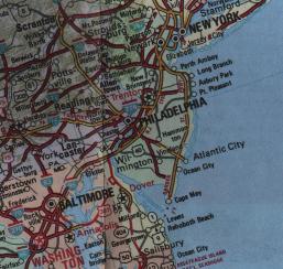
10) Phone message from Oriental, N.C.,
10-17-96. A map of this section of the
east coast is available here.
9-29-96, 37 58.68 N / 75 51.47 W Criss Field
10-1-96, 37 49.80 N / 75 59.66 W Tangier, met many people with very
distinct Cornish accents.
10-2-96, 37 42.43 N / 76 20.14 W Indian Creek, waited out a
low pressure region for three days.
10-5-96, 37 32.43 N / 76 20.14 W Fishing Bay
10-7-96, 36 56.62 N / 76 17.52 W Norfolk, VA. Couldn't find the
channel into Norfolk, ended up following a nuclear sub in. Saw many
aircraft carriers and subs in Navy Alley. Picked up liferaft from
repacking place.
10-8-96, 36 43.28 N / 76 14.49 W Great Bridge, entered
Inter-Coastal Waterway (ICW) (wrong turn in ICW, ended up a bit out
of the way)
10-11-96, 36 30.39 N / 76.21.33 W Dismal Swamp
10-12-96, 36 17.42 N / 76 13.08 W Elizabeth City
10-14-96, 35 40.30 N / 76 06.04 W Alligator River
10-15-96, 35 28.51 N / 76 32.28 W Slade Creek
10-16-96, 35 01.41 N / 76 41.93 W Oriental, NC
News: Waiting for another low pressure region to pass. Watching Hurricane
Lily carefully, will not go to the seaboard until Lily chooses her path.
Headed to Beaufort by early next week.
11) Phone call from Beaufort, N.C.,
10-21-96.
10-18-96, 35 56.02 N / 76 38.84 W Adams Creek
10-20-96, 34 42.73 N / 76 39.37 W Beaufort, NC
Friday, 10-18-96 forecast was for a severe cold front coming through so
tucked into Adams Creek. The front came through at 1am, 40 knots winds, anchor
held beautifully. Spent day in Beaufort, rented a car, shopped for groceries,
propane, and did laundry.
Plan on flying back to Wisconsin shortly after Thanksgiving for Kristin's
wedding shower and wedding.
12) Phone message from Charleston, S.C.,
11-2-96.
10-22-96, 34 33.07 N / 77 19.46 W Mile Hammock, NC
10-23-96, 34 00.12 N / 77 53.33 W Carolina Beach, NC, saw the
destruction of Hurricane Fran, docks out, roofs torn off, buildings torn in
half.
10-24-96, 33 44.03 N / 78 44.68 W Bearfoot Landing, SC
10-27-96, 33 33.62 N / 79 05.44 W Wakima River, SC
10-28-96, 33 21.81 N / 79 16.98 W Georgetown, SC
10-30-96, 33 09.04 N / 79 19.35 W South Sante River, SC
10-31-96, 32 46.83 N / 79 57.57 W Charleston, SC, site-seeing in
the renovated city for two days, walked all over the Battery.
Problem with the Ample Power system, I will try to help debug it from here.
13) Phone call from St. Augustine, FL,
11-14-96 and a message on 11-15-96.
11-4-96, 32 25.76 N / 80 40.70 W Beaufort, SC
11-5-96, 31 58.46 N / 81 03.19 W Isle of Hope, suburb of
Savannah, GA. Took bus into Savannah and saw all the old beautiful homes.
11-7-96, 31 27.58 N / 81 18.06 W New Tea Kettle River, had to
lay over a day because of strong winds.
11-9-96, 30 45.91 N / 81 28.34 W Cumberland Island, saw wild horses
and many seashells.
11-11-96, 30 03.09 N / 81 21.85 W Pine River, FL
11-12-96, 29 53.35 N / 81 18.87 W St. Augustine, FL, hauled boat to
fix shaft-seal leak.
Apparently there are no phones in Georgia so they could not call before
now. (!) Currently there is a gale blowing from the north. This is the second
day of it and it is expected to last two more days.
The shaft-seal for the propeller shaft was leaking and they were hesitant
to go offshore until it was fixed. They called the manufacturer and it is being
replaced for free. The boat has been out of the water since Wed 11-13-96 and
probably will not go back in until Mon 11-18-96. They are taking the
opportunity to put another coat of bottom paint on and check the zincs.
I talked them through the Ample Power problem and it turns out the
batteries are being charged just fine. The red charge light comes on when the
alternator is charging, I remember some incompatibility between the Yanmar
panel and Ample Power system. The panel was expecting 0v when charging and the
Ample Power system was putting out +12v when charging. Or vice versa. I
remember from when I installed it that it had to do with the charge light
only and shouldn't be a problem.
On the way down they stopped at Cumberland Island and hiked around on the
many hiking trails there. They saw wild horses running around the island. They
also toured Savannah and St. Augustine which they thought were some of the
prettiest cities they had ever seen.
After the boat is back in the water they are heading to Daytona to
re-provision. Apparently there is a supermarket right on the waterfront for
easy loading into the dingy. This is the first time they have re-provisioned
since May.
They will be leaving the boat in Titusville, FL (Near Cape Canaveral and
Orlando) which is three days away. They will be flying back on the Wednesday
after Thanksgiving (11-27-96) for Kristin's wedding. Their phone in Rice Lake
WI will be connected through December if you wish to call them. Their mailing
address is also valid through December but will change after that. I do not
have the new address yet.
14) Fax from Rice Lake, WI on 12-19-96.
One of the main characteristics of the trip is that the learning curve has
gone straight up and we thought we would include a few of the things we have
learned along the way:
All in all, (aside from Huron and Erie) we spent 2/3 night per month without
paid dockage (excluding haul-out and Titusville) and this was by choice. We had
fully planned to stay more in marinas, it had little to do with budget, we just
found the anchorages were prettier and more desirable to our way of cruising.
For years we used 50 ft chain and nylon rode with our primary anchors (35
lb. Delta, 33 lb. Bruce) and a lot of our friends thought that was overkill. In
preparation for the cruise, we changed to 70 ft of chain on each anchor. Two
thirds down the ICW, we added on chain so we now have 115 ft on each. This
means in most situations, we are anchoring on all chain and using nylon
snubbers. We can't began to tell you the difference this has made and wish we
had made the change before we left. Lesson: you don't have to have 250 ft of
chain on one anchor to be "anchoring on all chain" in most places state-side and
in the Bahamas. 125 feet does the job nicely - and without all the weight.
15) Phone message from
North Palm Beach, FL, 1-17-97.
11-22-96 29 13.62 N / 81 01.19 W Daytona Beach, FL
11-24-96 29 01.74 N / 80 54.66 W New Smyrna Beach, FL
11-25-96 28 37.21 N / 80 48.51 W Titusville, FL
On January 8th they arrived back at the boat after spending a month in
Wisconsin for Kristin's wedding. On the 11th, they got up at 4 am and saw the
shuttle launch at 4:20 am. Mom says it was stupendous and they could watch it
all the way up until the solid boosters separated.
1-11-97 28 33.13 N / 80 45.14 W Shuttle Anchorage
1-12-97 28 08.72 N / 80 36.29 W Indian Harbor Beach,
"The Dragon", FL
1-13-97 27 27.35 N / 80 18.29 W Fort Pierce, FL
1-15-97 26 50.28 N / 80 03.21 W North Palm Beach, Lake Worth, FL
They are waiting for good weather to cross over to Great Bahama Island. It
looks like it will be at least until Monday until the northerly wind lets
up.
Bought a backup GPS (Micrologic). Will leave 1-2am on Tuesday
morning. First head towards Fort Lauderdale then across to La Kia (sp?) or West
End. Bought shorty wetsuits and spears. Will call from Nassau in 2-3 weeks.
54) Fax from Georgetown, South Carolina, 6-3-99
5-22-99, Pine Island (St.M. 765)
11.5 nm from St. Augustine. A beautiful wilderness anchorage amidst the
marsh grass.
5-23-99, Cumberland Island (St.M. 718)
From Pine Island 48.4 nm. Would have liked to stay longer but a strong
south wind came up making the anchorage uncomfortable.
5-24-99, Jekyll Island (St.M. 684.6)
24.7 nm. Decided to break up the next long jump by staying at the Jekyll
Harbor Marina. Using the marina courtesy bikes we biked all over the island for
2 days visiting the beautiful old mansions in the Historic District, the dunes,
and remote sand beaches. They have 20 miles of paved biking trails, many
through wilderness areas. We saw a baby alligator.
5-27-99, New Tea Kettle River (St.M. 646.8)
33.7 nm, another beautiful wilderness anchorage in the marsh grass.
5-28-99, Isle of Hope (St.M. 590)
49.1 nm, anchored just outside the buoys to get more water and closer to
the marina.
5-29-99, Cowen Creek, S.C. (St.M 544)
41.7 nm. It makes a Big difference as to whether the tide is with you or
against you on running speed - 1.5 knots +/- the usual speed.
5-30-99, ??? River, S.C. (St.M. 513.5)
Stopped at Beaufort, S.C. for a couple hours to top off the fuel tanks at
City Marina, then went over to the Day Courtesy Dock. Walked around, had
lunch. Continue on - we gave "186" a large berth because of a Waterway Guide
warning but run out of water and aground with our 6'3" draft right in the
channel 20 feet from "184". Dead low tide. We were able to wiggle off after 10
minutes but still had lots of thin water for about 1/2 mile. Will have to
remember to take this one at least at half tide (tides run about 5 feet) in the
future.
5-31-99, Charleston, S.C. (St.M. 469)
Go under the bridge and anchor on the other side where there is less boat
traffic. Next day we take the courtesy shuttle out to West Marine, walk around,
visit the market stalls, and take the trolley.
6-2-99 South ??? River, S.C. (St.M. 415)
Our intentions were to stop at ??? Creek but we made such good time (6.5
knot average) that we kept on going. Thin water about 3 hours before low tide
but we didn't ground.
6-3-99 Georgetown S.C. (St.M. 408.9)
Leave at 0630 to take advantage of high water, 15.3 nm. Lunch ashore, spend
the afternoon walking around, this is one of our favorite ports of call.
55) Fax from Washington DC, 6-29-99
6-5-99, 33
33.76 N / 79 05.19 W, Bull Creek, S. Carolina (St.M. 381.4)
Beautiful cypress swamp. Anchored out in the open in the middle because we
heard reports from other boaters of snakes dropping down from the trees onto
boats. A good fuel stop is Wacca Wache Marina, St.M. 383.4.
6-6-99, 33
48.07 N / 78 44.75 W, Barefoot Landing, S. Carolina (St.M. 353.5)
Free dock right in the ICW. Neat shopping center with novelty stores (24.6 nm).
6-7-99, 33
51.48 N / 78 34.14 W, Little River Inlet, S. Carolina (St.M. 342.0)
Went 11 nm so we could get a jump on the flooding tide to run the Cape Fear
River on Tuesday. Anchorage to the left (north bound) appeared unsuitable
because of lack of depth so we were forced to anchor in the channel leading to
the ocean inlet. We were fortunate to have settled conditions and that the
tidal current was not too strong. Would not use this anchorage again as there
is some traffic of shrimp boats and casino boats.
6-8-99, 34
12.42 N / 77 47.94 W, Wrightsville Beach, N. Carolina (St.M. 283.4)
Up at 6 am to run the 36 nm to the Cape Fear River. With help of tidal
current are able to make good time and get there at 11:30 am and run up the
river with a flooding tide. Increasing water also helps with some of the
shallow spots in the Snow's Cut. Anchor 1.5 miles off of ICW below fixed
bridge. (52.6 nm)
6-9-99, 34
33.07 N / 77 19.45 W, Mile Hammock, N. Carolina (St.M. 244.5)
Time to get to Mile Hammock at 3/4 flooding tide as entrance is 5.5 feet
at low tide. We make it in with a little more than 1.5 feet under the keel with
our 6'3" draft (34.6 nm).
6-10-99, 34
43.00 N / 76 39.98 W, Beaufort, N. Carolina (2.1 St.M. off ICW 202.3)
Up at 5 am so we can leave on almost full tide (but no ebbing). This time
the lowest reading is 2.5 feet under the keel, 38 nm. It's been 3 years since
we left Bayfield, WI on this date.
6-11-99, 34
56.02 N / 76 38.97 W, Adams Creek, N. Carolina (St.M. 187.7)
Late start and strong current and wind against us so we don't make it to
Oriental. We anchor off in Adams Creek with 2 feet under the keel, 14.5 nm.
6-12-99, 35
01.39 N / 76 41.91 W, Oriental, N. Carolina (2.5 miles off St.M. 181.0)
A short day, 6.7 nm. Get there in time for breakfast at our favorite
restaurant - M&Ms. We walk around, an enjoyable day.
6-13-99, 35
28.51 N / 76 32.31 W, Slade Creek, N. Carolina (St.M. 140.4)
A beautiful anchorage off in the side creek and trees, marsh grass and
wildlife, 38.9 nm.
6-14-99, 35
56.12 N / 76 01.47 W, Little Alligator River, (St.M. 81.9)
A long day, 53.9 nm. But wanted to be in good position for crossing Albe
Marle (sp?) Sound.
6-15-99, 36
21.01 N / 75 56.88 W, Coinjock, Virginia (St.M. 49.5)
Left early to cross the sound, wind S 10-12 knots, little sea, but rain and
mist. Top off the fuel tanks at Coinjock.
6-16-99, 36
43.24 N / 76 14.25 W, Great Bridge, Virginia (St.M. 12)
Strong winds (20-25 knots) crossing the sound. Once again the stay-sail
bailed us out and we were able to make double the speed as other sailboats
crossing with us. It is so nice having that little sail on a furler and ready
to go. In Great Bridge stayed at the free dock just south of the bridge as the
one between the bridge and lock was full. While in Great Bridge took local
buses (with transfer) to an outer Norfolk shopping mall to see the new Star
Wars movie.
6-19-99, 36
50.61 N / 76 17.51 W, Norfolk, Virginia (St.M. 0)
The last 12 miles of the ICW and we're done! From Ft. Pierce - 966 St.M. in
5 1/2 weeks. Tied up at Waterside Marina, downtown Norfolk, had supper out to
celebrate. Rain.
6-20-99, 37
01.42 N / 76 20.45 W, Hampton, VA
Rain and drizzle. Went up the Hampton River to anchor off the town - 12.8
nm. Next day visited the huge contemporary Air and Space Center. Fantastic
exhibits and great IMAX films. We liked it better than the Kennedy Space
Center.
6-22-99, 37
00.43 N / 76 18.99 W, Fort Monroe, VA
More rain and drizzle, 2.3 miles round the corner to the military basin at
Fort Monroe. Visit the fort. We looked out onto Hampton Roads where the
Merrimac and Monitor fought their famous battle.
6-23-99, 37
32.92 N / 76 19.87 W, Jackson Creek, VA
Wind NE 10, 42.5 nm, into Chesapeake Bay at last.
6-24-99, 37
58.18 N / 76 27.59 W, Coan River, Potomac River
Up and around into the Potomac to begin our trek up to Washington D.C for
the 4th of July, 42.7 nm. Coan River is on the Virginia side, a little tight
getting into the branch we went into. We touch bottom between markers 12 and 13.
6-25-99, 38
11.51 N / 76 26.06 W, St. Mary's City, MD
Went across to the Maryland side and up the St. Mary's River to visit
historic St. Mary's City. Not as much as we expected but the replica of the 56
foot pinnace DOVE which brought the first Maryland settlers across the Atlantic.
6-26-99, 38
25.44 N / 77 00.78 W, Tobacco River, Potomac River
The Potomac is a very big river, 10 miles wide at the mouth. Once again the
effects of tide become apparent on our speed and we are able to make good time,
44 nm. Unfortunately most of the tributaries are too shallow for us to anchor
in, but we get 11 feet in the Tobacco River.
6-27-99, 38
46.79 N / 77 01.96 W, Smoot's Cove, Potomac River
Another 44 miles up the river. On both days we have been fortunate to have
a following wind so have been able to roll out the genny. Five miles south of
Washington D.C. is the Wilson Memorial Bridge with a vertical clearance of 50
feet (our mast with antennas is about 54 feet). So we have to wait for a bridge
opening which is often from midnight to 4 or 5 am. Anchor off in 10 feet 1 mile
below the bridge.
6-28-99, 38
52.64 N / 77 01.52 W, Washington Channel, Washington D.C.
We luck out and get wind of a 1230 bridge opening for an ocean freighter
and get to pass through in it's wake in daylight. Set anchor off the Capitol
Yacht Club. Glad we came a few days early because we get a good spot and hear
it is going to fill up fast now for the 4th. Register at Gangplank Marina, $25
week for secured dingy dockage and use of all facilities. Helicopters buzz the
anchorage close overhead. We can see the Washington Monument. Tomorrow we will
start taking in the sights beginning with the Smithsonian.
56) Fax from Washington DC, 6-29-99
7-4-99, 38
52.64 N / 77 01.52 W, Washington D.C.
You know how they talk about "wind chill", well here it is the "heat
index". Projections for today are 105-110 degrees F. They call it Code Orange.
Washington D.C. is experiencing a heat wave. Yesterday it was low 90's with
humidity to match. Today it is supposed to reach the high 90's-100, maybe even
greater according to the TV. So we have all of our Venezuelan defenses out -
side curtains on the bimini, awnings over the main and foredeck. And of course,
fans. It all really helps and we aren't that uncomfortable. We plan on pretty
much staying on the boat today and staying cool. We'll watch the fireworks as
they shoot out over the Potomac from between the Lincoln and Washington
Monuments. Besides we have been going pretty strong and have declared this a
rest day.
We just love D.C. We have been leaving every morning around 8-9 and getting
back to the boat around 6-7 each night. We have visited the Air and Space
Museum (spectacular - great IMAX movies), Arts and Industries, National
Aquarium, Hirshorn Museum (modern art), Smithsonian Institute, National
Gallery of Art (2 buildings), White House visitor center, Washington Monument,
Lincoln Memorial, and even took a bus to Mt. Vernon 14 miles away. Probably our
most exciting adventure is that we have braved, and more important, conquered
the Metro. This feat of contemporary engineering is a massive underground
subway system that links all of D.C. through intricate tunnels, criss-crossing
sub-lines, and efficient stations, transfer points, etc. Using the Metro we
went out to the National Zoo (fantastic) and spent another day at National
Geographic Explorer Museum (double fantastic). We were only going to stay a
week but it looks like we are going to have to stay at least another as there
are so many more places we want to see including the Natural History Museum,
the Navy Memorial Heritage Center, the FDR Museum, and Arlington Cemetery. They
call D.C. a grand political/historical theme park and they are right.
57) Letter Annapolis, 7-29-99
7-14-99, 38
48.73 N / 77 02.29 W, Alexandria, Virginia
Finally pulled anchor in D.C. and motored around to James Creek marina to
take on fuel and water. Then motored 5 miles downstream to Old Town Alexandria,
where we tied off on the city dock for $5.00. Spent the afternoon wandering
through beautifully restored Old Town visiting many of the quaint shops. We had
previously called the Woodrow Wilson Bridge via telephone (202 727-5522) to
arrange for a midnight opening. So at 11:30 pm left the dock to get in position
and at 12:02 the bridge opened for us. Set anchor at 12:30 1 mile downstream in
Smoots Cove where we had been before and went to bed.
7-15-99, 38
25.52 N / 77 00.75 W, Tobacco River (Potomac)
This anchorage really breaks up the trip up or down the Potomac nicely into
two 44 mile days.
7-16-99, 38
01.50 N / 76 34.43 W, Yeocomico River (Potomac)
Anchored in a cove off the town of Kinsale. On Sat visited cruising friends
from South Africa. Went swimming in the pool - it was 95 deg.
7-18-99, 38
24.85 N / 76 29.07 W, St. Leonard Creek, (Patuxent)
One of the more beautiful places we've been to in the Chesapeake. Wooded
bluffs to each side, a few homes. It's hot - 95 deg- but we are blest with a
cool breeze. Unfortunately, we can't go swimming because of the jelly fish, but
we manage some 'pool time' at a restaurant marina that we dinghy to.
7-20-99, 38
20.22 N / 76 27.62 W, Back Creek (Solomon's)
Lots of boats. Anchor in Back Creek, adjacent to the Holiday Inn. This is
convenient to a laundromat, post office, restaurants and an outstanding grocery
store and deli. We visit the various marinas and chandleries. Have the
sun-damaged window in the dodger replaced. Visit with the Damerells,
circumnavigator cruising friends we met years ago in North Channel.
7-2-99, 38
58.52 N / 76 28.94 W, Spa Creek, Annapolis
Hot and muggy - pick up a mooring at $15/night - we sign up for a week at
$85. Annapolis is GREAT FUN with lots to do. Ron is like a kid in a candy shop
with all the marine stores. Take a local bus to a suburb of Baltimore to get
our computer printer repaired. Travel time - 1 hr 15 min one way, all for $1.35
- wow!
58) Email from St. Michaels
8-2-99, 39
04.92 N / 76 07.44 W, Corsica River
Finally went across to the other side of the Chesapeake into the Chester
River on the Eastern Shore. It is quite a change from the western shore being
more wild, less built up and lots of wildlife. The Corsica is a tributary of
the Chester River and one of our favorites in the Chesapeake. It also makes
a nice stopover to break up the long trip up to Chestertown.
8-3-99, 39
12.35 N / 76 03.77 W, Chestertown
Another 14 miles up this beautiful deep navigable river to Chestertown.
Anchored off the town in lieu of the town marina which we thought was too
pricey for the area and what you get ($1.25/foot/night). Chestertown is
different from the hussle of the cities and towns on the Western Shore and we
thoroughly enjoy lots of hiking and visiting quaint shops and restaurants. Meet
Great Lakes sailors from years past, Bill and Debbie Denton who invite us over
to the house they are renting for the summer.
8-7-99, 39
05.01 N / 76 06.76 W, Corsica River
This time we go further up the Corsica and spend a few days. Still have
lots of stinging nettles (jelly fish) so we can't swim. Are also visited by
lots of rays with their wing tips looking like 2 shark fins.
8-9-99, 38
47.35 N / 76 13.18 W, St. Michaels
Make the long trek around Tilghman Island (47 nm) as opposed to Kent
Narrows (which would have cut off approximately 25 nm). Considered going
through the narrows which are dredged to 7 feet at high tide with our 6 ft plus
draft. But high tide was at 1800 which would have meant getting in late and a
strong northerly wind would have made the approach to the buoyed channel
tricky. Besides we couldn't pass up the opportunity to have a great sail.
St. Michaels has to be one of the neatest places on the Chesapeake. A
boaters mecca, it caters to transients with a nice dinghy dock, neat shops and
restaurants, lots of good walking and very nice people. It's hot and humid again
with everyone complaining - but it's nothing like Venezuela or the offshore
islands.
59) Phone call from Western Chesapeake
8-14-99, 38
53.18 N / 76 09.27 W, Dividing Creek, Wye River
A beautiful wilderness anchorage with lots of wildlife. On Sunday the
engine wouldn't start when we went to run refrigeration. Changed the solenoid -
nothing; changed the ignition switch - nothing; put in a completely new starter
and bingo - the engine started. How many times have we been glad to have
replacement parts on hand. We didn't leave with an extra starter, but ordered
one from the Turks and Caicos when a starter on a friend's boat died. Figured
if it could happen to him, it could happen to us.
8-16-99, 38
47.19 N / 76 13.09 W, St. Michael's
Went back into St. Michael's for one more day.
8-17-99, 38
42.52 N / 76 09.97 W, Oxford
Anchored off to the side, just outside inner channel buoys - 1.5 ft under
the keel. Oxford is a quaint sleepy little town with very friendly people.
8-19-99, 38
38.06 N / 76 06.63 W, La Trappe Creek-Choptank R.
One of the most beautiful anchorages in all of the Chesapeake. On the
second day woke up to cold fog and mist rising up from the water - brought back
memories of L. Superior.
8-21-99, 38
34.31 N / 76 04.45 W, Cambridge on the Choptank River
According to the GPS, today we turned 10,000 nm since leaving Bayfield over
3 years ago. Cambridge has a large FREE DOCK for transients right in front of
the Dorchester County House. A couple of mile hike takes us to a number of
shopping malls which include K-Mart, Wallmart and of course fast food. It's a
nice change from the wilderness areas - Chesapeake has everything.
--Bonnie
8-28-99, email from Cambridge
We are still in Cambridge keeping a close eye on Dennis the Menace. Since
Dennis has stalled, we are going to make a run for the Potomac: leaving
tomorrow (Sunday) for the Solomons on the west side and then Monday another 40
miles to Port Kinsale Marina on the Potomac. At this point it doesn't look like
Dennis is going to cause to much of a problem in the Chesapeake, but with
hurricanes - you never know.
8-30-99, phone call from Port Kinsale Marina in Solomon Islands on western
edge of Chesapeake
They are riding out Dennis in a marina since they ran out of time trying
to get up the Potomac River. There is a cold front from Minnesota complicating
things by causing even more wind. Norfolk and Hampton are flooding nearby and
the wind is around 47 knots but not getting worse. --pete
9-6-99, Email from Port Kinsale Marina
We are finally over Dennis after tracking the fellow for over 2 weeks. The
storm finally went ashore south of us and quickly dissipated. The strongest
winds we had were around 30 knots, but we are tucked in and sheltered so well,
we hardly felt them. Had quite a bit of rain on Sunday and the water level rose
quite high - over the docks at high tide. So we were 'boat bound' for a number
of hours.
Ron is busy working on the boat. The painted aluminum cleats really
'packed it in', so we are replacing all of them with new stainless cleats. Are
also replacing the down wind pole ends with new custom made stainless ones, and
stainless deck chocks for the poles for those times we don't stow them on the
mast. Also got a new custom made stainless anchor holder for the stern
anchors. We are also doing a lot of cleaning - clearing out the lockers of a
lot of accumulated 'stuff'. Some we are sending home in boxes, other we are
just throwing away. It's amazing what you can accumulate in 3 years of
cruising.
Have more time now - because the couple I came to the library with have a
couple of hours of work on the computer to do. They are from South Africa, we
meet them when we were in Venezuela and have cruised with them a number of
different times. They have bought an old used car because they plan on spending
a few years off and on in the States.
60) Email from Port Kinsale
8-29-99, 38
19.81 N / 76 27.03 W, Mill Creek, Solomons
Had a nice sail down to the Solomon's. Anchored in Mill Creek because there
is more swinging room and were expecting a blow during the night. Sure enough
it hit at 0200 - 20/25 knots.
8-30-99, 38
19.97 N / 76 27.65 W, Back Creek, Solomons
Went around to Back Creek where there are more amenities, stores
etc. Waited a couple of days to have a special stainless bracket for the
mast-head welded. Blustery weather continues.
9-2-99, 38
01.84 N / 76 33.35 W, Port Kinsale Marina, Yeocomico River off the Potomac
Had a great sail off the wind (NE 20/25 knots) down to the Potomac and then
about 9 miles up the Potomac to the Yeocomico R. Have booked a month at a small
remote marina to get some boat work done. We are in an especially secure corner
which was evidence on Sunday. Dennis the Menace finally made up his mind after
stalling for days off C. Hatteras and came on shore Saturday, just south of the
Chesapeake. By time it's outer reaches got to us on Sunday we had only 25 knots
of wind (which we barely felt tied up behind a large wind break and spit of
land) and lots of rain. The water rose quite a bit, especially at high tide,
and our dock was well under so we were 'boat bound' for much of the day.The
area is quite beautiful with lots of forests of southern pine and wildlife in
the adjacent wet lands. We are with 2 other cruising boats from South Africa,
friends we met in Venezuela and on the ICW.
61) 9-15-99, noon, phone message from Port
Kinsale Marina
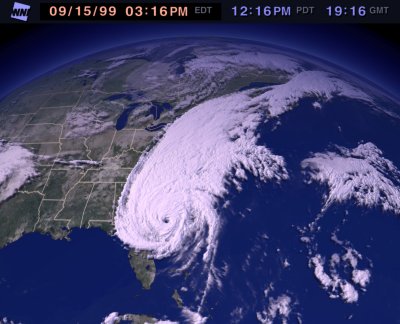
They are ok but right in the path of Hurricane Floyd. Floyd is expected
to come ashore tonight in S. Carolina and will reach them Thursday
(9-16-99). They hope it will lessen but are looking for shelter now. They do
not know if they will stay with the boat. Currently Floyd is Category 3, 125
mph winds. --pete
Here are the current pictures (2 pm PST, 9-15-99):
9-17-99, phone call from Port Kinsale Marina:
They are ok, Floyd veered NE and lost some power as it hit. The eye
passed 80 miles to the east of their location. The worst wind they saw was 30
knots and they experienced lots of rain. There was 65 knots of wind in the open
part of Chesapeake Bay. The docks at Kinsale Marina were under water due to the
surge and they had to wade ashore on the dock. They had double docklines going
to the structure of the dock and two stern anchors out with full scope into the
harbor. To get from the dock to the boat they had two lines and walked across
those. They removed the genoa and lapper from their furlers but left the main
and inner foresail on but wrapped with line to keep them furled. They were hit
by the NW quadrant of Floyd which is much better than being hit by the NE
quadrant where the hurricane's speed ads to the wind strength (Floyd was
traveling at 30 mph northward). The hurricane hit about 3:30 am Thursday
morning. That morning around 8 am Bonnie left the boat with friends for a
nearby brick house with basement, Ron stayed with the boat. By Thursday evening
the worst was past. --pete
62) 9-27-99, email message from Port
Kinsale Marina
We are beginning to wind down boat work and start getting ready to head
south. It would be nice to be at the Annapolis Boat Show and meet the people in
the e-mails, but then we wouldn't make it in time to fly home for
Thanksgiving. Guess you can't have everything. We hope to start heading south
out of the Chesapeake on Monday, 4 October. That is of course weather
permitting. It's three days to Great Bridge, Virgina - which is another good
spot to weather storms. They also have a library there where we can check out
hurricanes etc. before heading out across the large sounds. But from then on,
we're pretty vulnerable. I figure we have to leave Great Bridge by 15 October
to make it to Titusville by mid-November.
10-1-99, email from Port Kinsale
We plan on leaving Port Kinsale early Monday morning and weather permitting
should be in Great Bridge by Wednesday afternoon. Will spend a few days there,
probably through Saturday, because we are having the starter that 'packed it
in' repaired there and there is a library close by where we can check on
weather/hurricanes etc. Great Bridge is the last really good protection for
storms and then we have a couple of large sounds to cross before we get on the
other side of Cape Hatteras. So we want to be pretty sure of the weather before
we leave there.
63) 10-7-99, email message from Great Bridge, VA
10-4-99, 37
32.69 N / 76 20.07 W, Jackson Creek, VA
It's getting colder, the days are getting shorter, the geese are a honkin'
and flying over head - headed south - and it's time we do likewise. Our month
at Port Kinsale proved worthwhile - we got lots of boat work done AND it proved
a GREAT place to weather hurricanes. We set anchor in Jackson Creek with lots
of cruising boats - all who got up and headed out early the next morning. And
so we 'join the pack'.
10-5-99, 37
00.42 N / 76 18.90 W, Fort Monroe, VA
A cold blustery day - but had a fantastic door-to-door sail on strong
northly winds - reminded us a lot like sailing on L. Superior in the fall. A
good day to be headed south.
10-6-99, 36
43.29 N / 76 14.51 W, Great Bridge, VA
Statute Mile 11.5. This was our 3rd time going by Navy Alley and through
Norfolk and as always it was really interesting seeing all the submarines,
aircraft carriers, container ships from foreign ports being loaded. We are
stopping at Great Bridge to stock up on supplies, pick up our repaired starter
(now our spare) and get the latest updates on tropical depressions before
heading down the ICW. On each opening of the lock there is a flood of boats
heading south - at least a dozen each time and the lock opens passes boats
through just before each hour in time to make the opening bridge.
10-8-99 email from Great Bridge
We have decided not to lay over tomorrow but head out once again. This
gives us an extra day for inclement weather or what-ever. Besides, as we see
all the boats passing us by it makes us anxious to get going too. We have just
looked at the hurricane site. Tropical depression 11 along the east coast of
Mexico has dissappated, TD 12 east of the lesser Antilles looks like it will
probably do the same in the next 24 hours. Hopefully, as we continue into
October the chance for TD gets less with each day passage and nothing will
build or reach the U.S.
Don't know when I'll get on-line again. We have 4 or 5 days of wilderness
travel before we get to another town (Oriental, NC) and we aren't sure if
they have a library there. But we'll keep in touch.
--Bonnie
Inter-Coastal Waterway:
Bonnie Dahl
Their new mailing address (effective immediately) is:
Ron & Bonnie Dahl
PMB #327, 88005 Overseas Highway, Suite #9
Islamorada, FL 33036-3087
